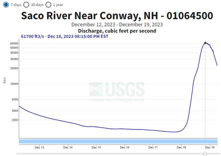
The Saco River in Conway went from a gentle stream to a raging torrent during the storm on Dec. 18, 2023. The river’s flow went from about 1,000 cubic feet per second to nearly 62,000 cubic feet over the course of 20 hours.
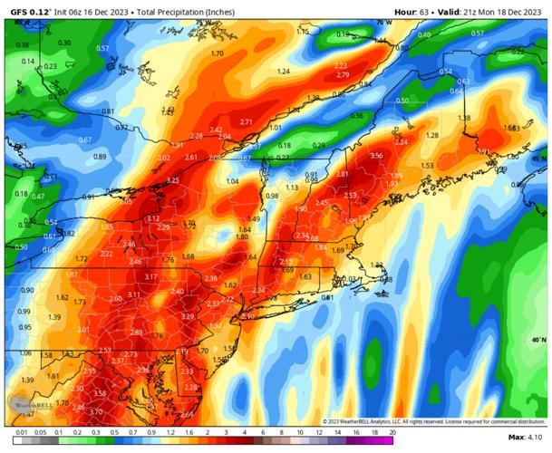
The Global Forecast System model of total precipitation two days before the storm shows the heaviest precipitation in two tracks, with the more easterly track flowing up over western New Hampshire and the White Mountains.
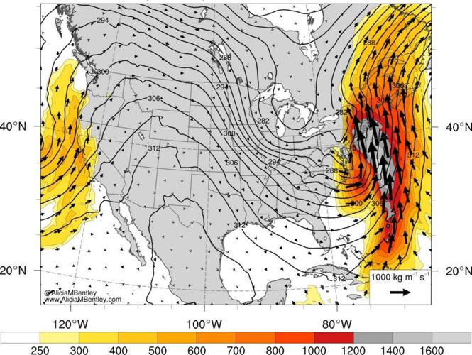
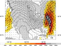
This image shows the forecast for Integrated Water Vapor Transport (IVT) from a week before the Dec. 18 storm. This plume of moisture signaled the potential for a heavy rainfall event a week before the event.
The Global Forecast System model of total precipitation two days before the storm shows the heaviest precipitation in two tracks, with the more easterly track flowing up over western New Hampshire and the White Mountains.
In a typical 9-5 workday, challenges at the office often include jammed printers, demanding customers, and the occasional spilled coffee. However, for weather observers stationed atop the Rock Pile, a tough day at the “office” unfolds in a realm of chaos and extremes.
One remarkable instance occurred on Dec. 18, 2023, when a freak storm shattered temperature and precipitation records across the Eastern Seaboard, leaving its mark all the way up to the top of New England, forever etching itself in the summit’s rich meteorological history.
Get ready for a tale of weather at its worst and observers at their best.
The first hints of trouble emerged a week before the event as we examined weather model guidance.
Starting on Dec. 7, the Global Forecast System produced a forecast that featured a strong area of low pressure tracking from the central U.S. up through the Great Lakes. This track put the entire East Coast firmly in the warm side of the storm with a strong flow of air all the way from deep in the tropics. The forecasted 1,000-mile-plus fetch of moist winds and highly unusual warmth began to alert the summit crew and many meteorologists to the potential for a snowpack-wrecking rain and wind storm of epic proportions.
Zooming ahead to 48 hours before the event, within the scope of our Higher Summits Forecast, the murmurings and signs of a potent storm had been proven true — a testament to just how far forecasting has come.
Even with a decent amount of forecast consistency, a storm of this magnitude always causes a bit of disagreement and good-spirited debate among observatory staff. What was clear at T-minus-48 hours was that there was going to be a rain and wind storm. The devil, of course, is always in the details.
On the 16th, model guidance suggested that the strongest winds would remain to the east of the summits, associated with what meteorologists call a low-level jet (LLJ)—a region of strong winds in the lower part of the atmosphere, specifically powerful low-level southerly winds.
The low-level jet associated with this particular storm was forecast to stretch from the Bahamas to Montreal, a mind-boggling distance of 1,600 miles, leaving no question that this was going to be a high-end event.
In my mind, the storm would track to the west of the White Mountains, putting the summits squarely in the worst of the narrow but powerful LLJ, resulting in a maximum wind gust of 150 mph — an impressive gale and a personal victory for me, having forecasted 150 mph winds. Colleagues Karl and Ryan had a more level-headed argument, suggesting that the storm would take a more easterly track and thus produce lower maximum winds.
This image shows the forecast for Integrated Water Vapor Transport (IVT) from a week before the Dec. 18 storm. This plume of moisture signaled the potential for a heavy rainfall event a week before the event.
Mount Washington Observatory
Lighting the fuse
Around the time of our deliberations and debates, the storm was beginning to take shape over the Gulf of Mexico, and deep swaths of tropical moisture were starting to stream northward, creating an expanding dense cloud shield. Underneath these clouds, clusters of heavy rainfall and thunderstorms were forming. The fuse was lit for what was going to be a storm to remember.
At 24 hours before the storm, the meteorologists at the National Weather Service office in Gray, Maine, formally issued a flood watch for the White Mountains. The language of this particular watch was as strong as I’ve ever seen, detailing a risk of 3 to 6 inches of rainfall and rapid snowmelt. Computer-model guidance was painting an even more alarming picture of 6 to 10 inches of rain.
Prior to the heavy rainfall, the summits saw a prolonged period of above-freezing temperatures that served to warm the 10- to 30-inch snowpack to near freezing. This phenomenon, called ripening, almost always precedes a significant snow-melt flooding event, as a snowpack near freezing can melt all at once. While strong higher summit winds were still a concern, the central focus quickly became flash and river flooding.
After a week of waiting, forecasting, and fine-tuning our numbers, the storm was finally here. The low center raced from the Gulf of Mexico to coastal South Carolina in a mere 24 hours, and then up the rest of the Eastern Seaboard and into the White Mountains just 15 hours after that.
Then it hit
The storm began with a brief period of moderate to heavy snow, which then quickly transitioned into an icy, sleety mess as the low-level jet that we had spent a week forecasting was now transporting warm air northward and changing snow above the summits into an increasingly heavy rainfall.
Overnight, our night observer bravely measured the strongest wind of the storm (132 mph), or the equivalent of a low-end Category 4 hurricane. Of course, this wind gust was accompanied by driving sleet and heavy rates of icing that exceeded 6 inches per hour.
The first thing that I noticed as I woke up was the silence. Typically, winds above 100 mph feature a sound many compare to a freight train or jet airplane taking off, but things on our side of the Sherman Adams summit building were eerily quiet. This all changed as soon as I got to the deck door to start the day’s observations.
The Saco River in Conway went from a gentle stream to a raging torrent during the storm on Dec. 18, 2023. The river’s flow went from about 1,000 cubic feet per second to nearly 62,000 cubic feet over the course of 20 hours.
MOUNT WASHINGTON OBSERVATORY
The first thing I noticed was how violently the door was rattling and flexing in the 85 to 95 mph wind. To continue our observations, Karl and I opted to take them up at the top of our 60-foot-tall tower. While this sounds counterintuitive and dangerous, the tower is fashioned with what is likely the strongest wall in the world to help shield us from the worst of the winds.
We spent several minutes at a time watching the Hayes chart bounce around with each powerful gust. This is about the time when I noticed a substantial dripping sound — the tower was flooding! The southeast wind paired with the driving rain to bring the deluge down into our iconic tower.
Typically, flooding in the tower is remedied by attaching a sump pump to a hose to simply pump the excess water out of our living quarters. This storm, of course, had other ideas for us. The powerful southeast winds meant that once the door was opened it would be nearly impossible to close. To boot, the base of the tower was still surrounded by feet of hard-packed snow, so bailing the water out below wasn’t going to be an option either.
We ended up using the sump pump to pump the roughly 6 inches of water into a mop bucket. As you might imagine, this took a while, but Karl and I eventually got a rhythm going using the duck alarm on his phone to signal the next bucket change.
At one point, the alarm started quacking during one of our live radio broadcasts, and it made for the perfect comedic break from an otherwise tragic day.
Flooding everywhere
Outside of 4 inches of rain, some flooding, and a Category 4 hurricane-force wind gust, life at the observatory more or less carried on as normal. Nimbus, our summit cat, was barely roused from one of his legendary 10-hour naps; it seemed as though every creature on the summit, feline or human, was unaware of the unfolding chaos below.
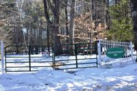
At the base of the mountain, the typically calming Peabody River was rising into a torrent . Eventually, the water rose to all-time record levels, washing out the majority of the parking lot along the way. Other rivers also set records, including the Saco near Conway, which crested at 17.71 feet, surpassing the record set during Tropical Storm Irene of 17.23 feet in 2011.
Along many rivers on the East Coast, this was a once-in-a-century event that destroyed numerous landmarks, including bridges, roadways, homes and more tragically, a handful of lives. Power outages across New England left millions in the dark as a freakishly strong low-level jet of 80-110 mph was able to mix close to the surface.
I won’t soon forget having to pump out inches of water from the tower or seeing most of our parking lot eroded from record high river levels. I will forever hate this storm as it showed me that a single rain event can, in the new climate, erase a season’s worth of snowfall.
Francis Tarasiewicz is a weather observer/education specialist at the Mount Washington Observatory. To learn more about the observatory, visit mountwashington.org. Atop the Rockpile appears monthly in the Sunday News.


